New York State flooding & climate change resilience studies
- Client Name
- Resilient NY Program
- Location
- New York, USA

This project received the 2025 Silver Engineering Excellence Award in Studies, Research, and Consulting Engineering Services from the American Council of Engineering Companies of New York (ACEC New York)
Challenge
The Resilient NY Program began in November 2018, when the New York State Department of Environmental Conservation (NYS DEC) and the New York State Office of General Services (NYS OGS) launched the program with the goal of improving community resiliency to extreme weather and ice jam events that result in flooding. High-priority watersheds have been selected by NYSDEC based on several factors, such as frequency and severity of flooding and ice jam formations, extent of previous flood damage, and susceptibility to future flood events. Under the Resilient NY Program, SLR was selected to conduct flood analyses throughout eastern New York State.

Solution
SLR’s approach to each flood study entails four main steps:
- Stakeholder outreach
- Data collection
- Flood mitigation analysis
- Reporting
Stakeholder outreach
SLR begins each flood study by conducting outreach meetings with stakeholders to gather information about flood history, property damages, and high-water levels, which helps us to understand flooding problems and calibrate our hydraulic models. Stakeholders include state and county agencies, local municipal officials, departments of public works, emergency responders, county soil and water conservation districts, watershed groups, and other interested parties.
Data collection
SLR staff research and gather relevant data on the history and causes of flooding and ice jam formations in each watershed. We conduct river corridor and watershed inspection to identify problem areas and flood and ice jam hazards and characterize fluvial features affecting problem areas, including channel bends, flow constrictions, changes in valley confinement, large wood-buildup areas, major bank failures, floodplain encroachments, channel straightening, dredging, channel incision, and aggradation. We gather field measurements of bridges, dams, culverts, and other stream features.

Flood mitigation analysis
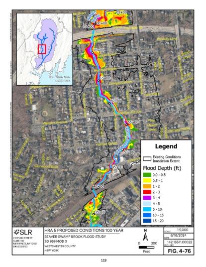
SLR’s Water Resources Engineers and Scientists conduct a hydrologic assessment for a range of flood flows at various points within the watershed. We conduct hydraulic modeling that simulates flooding and ice jamming, develop flood mitigation alternatives, then each alternative is modeled and evaluated to determine whether it results in a reduction in flood depth and lateral flooding extent. Modeling results are conveyed using depth grid mapping, which allows viewers to easily understand the flood reduction benefits of each alternative.
Reporting
Each study results in a concise report recommending a range of flood mitigation projects and a recommended implementation plan. Planning level cost opinions and potential funding opportunities are provided. Each project ends with a stakeholder closeout meeting, where the flood mitigation recommendations are explained, and the final report is distributed.
The studies incorporate future conditions scenarios using climate change forecasts and projections. Modeling results are conveyed using easy-to-understand graphics.
Examples of SLR's Reporting Graphics
SLR has completed 26 flood study reports to date and is currently working on several more.
Impact
The recommendations provided in these flood studies provide flood prone towns and villages with a much-needed short- and long-term blueprint, or path forward, to mitigate flooding in their communities. Some of the recommendations can be acted upon right away, while others require community buy-in, acquisition of flood prone properties, engineering design, agency approvals, and securement of project funding, and therefore take longer to implement. Many flood mitigation recommendations made by SLR have gone on to the design and implementation stages. Several flood mitigation projects are now fully constructed. Examples include:
- Steele Creek Flood Mitigation and Channel Restoration Project, Village of Ilion, Herkimer County
- Fulmer Creek GreenPlain, Town of German Flats and Village of Mohawk, Herkimer County
- Main Street Bridge Replacement and Dam Removal; Village of Frankfort, Herkimer County
- Sauquoit Creek Flood Mitigation Projects, Oneida County
SLR’s flood analyses conducted under the Resilient NY Program have exceeded the needs and expectations of our clients: the New York State Department of Environmental Conservation and the New York State Office of General Services. The flood studies have also provided valuable and much-needed guidance to flood prone communities all across eastern New York State.


